

|
The boundaries of the civil parish of Witheridge can easily be followed on the first series 1:25,000 Ordinance Survey Maps, Witheridge SS81 and Chawleigh SS71. From the maps it can be seen that the boundary line makes use of watercourses in order to provide a physical demarcation from adjacent parishes. Where suitable watercourses are unavailable, the boundary line is co-incident with hedgerows, mostly continuous, almost straight, hedgebanks that betray their antiquity by the way they run across country with other hedges butting up against them on either side'. To quote Professor W. G. Hoskins, who considers parish boundaries (at least ecclesiastical parish boundaries) to date from the times of the Norman Conquest and the implication of the features described is that these hedgebanks predate the adjacent field hedges and were a deliberate construction to identify the parish limit. The map observations on boundary hedges can be confirmed in the field and are large earth structures. It is noticeable that in several locations where a boundary line crosses the highway, the boundary hedge is encroaches onto the roadside verge. This feature is not exclusive to boundary hedges, there are other places where a similar feature is evident. Is this indicative of other ancient hedgebanks? Similarly, when the parish boundary follows a road side hedge, a bulge can be detected where the boundary changes to the opposite side, this coinciding with a slight change in line on the O.S. Map. For Witheridge, the civil parish established by the Order of March 28th 1885, which tidied up the boundaries, does not coincide with the ecclesiastical parish, which is constituted of the modern civil parish plus three separate outliers in the midst of adjacent parishes. These are the large southern outlier extending from Cann's Mill and Thelbridge in the west to Nomansland in the east, Yeatheridge, and Little Witheridge. The boundaries for these outliers are not defined as such on the 2.5-inch map, but can be readily postulated, at least for Yeatheridge and the large southern outlier, using the sort of features forming what is now the civil parish boundary. Subsequently the limits of the outliers have been confirmed on the Tithe Map of 1842 in the Devon County Record Office. The first series 2.5-inch map also records the presence of the boundary stones around the parish, where highways are cut or where the boundary is a roadside hedge. These markers are fairly substantial and roughly triangular in shape, with two smooth faces with parish names tooled in. I have listed the located stones with map references, because several marked on the first series map have already disappeared, and the others are in the process of being covered with ditchings, and one stone is sheared off and disappearing into the mire. The second series 2.5-inch map does not give a complete picture of existing stones. In summary, there are eleven stones around the civil parish, four around the southern outlier, two in Yeatheridge, and two in Little Witheridge. The southern outlier, now in Thelbridge civil parish, and Yeatheridge, now in Worlington, have stones inscribed 'Witheridge'. Witheridge Parish seems to have been particularly well endowed with these markers. It would be interesting to know why. Does it relate to difficulties in enforcing Parish Poor Laws in such a scattered Parish? Obviously, the stones predate the creation of the civil parish, and I have found a reference to boundary stones in the Witheridge Vestry Minute Books for the year 1860. This read: "Notice is given that a Vestry Meeting will be held at the vestry in and for the Parish on Thursday the 26th January next at 4 o'clock in the afternoon for the purpose of deciding what sorts of posts should be put to the boundaries of the above Parish". The result was recorded as follows:- "It was unanimously resolved that the power be granted to the Waywardens of the Parish to set up Boundary marks at the several points required according to the best of their judgment". The Waywardens were William Bragg, Matthew Mogford, Joseph Cole and George Wreford. The Map below was made from the 6" Ordnance Map to illustrate the Boundaries of the Ancient Borough Of Witheridge using information provided in 1937 by Mr H H Churchill. 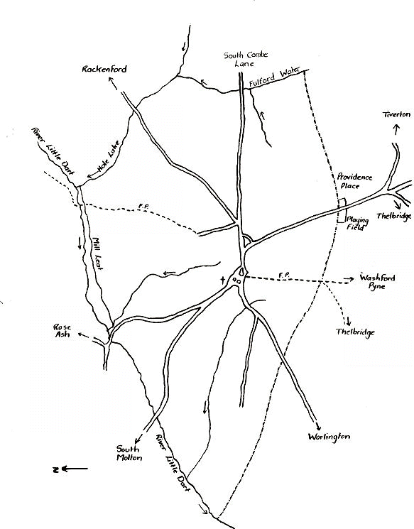
Previous Last Edited 03/07/2006 Copyright © 2000-2006 Witheridge Unless otherwise indicated on the page in question, the photographic images reproduced on this site belong to the Witheridge Archives, and, as such may not be reproduced for commercial purposes without written permission. However, you are welcome to use any of the photographs belonging to the archive for personal and/or non-commercial use. Any material shown as not being owned by the archive may not be reproduced in any form without first receiving written permission from the owner of the material in question. |